Posts

Showing posts with the label Skywatch

Where There's Smoke...
Image
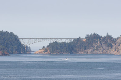
Yesterday morning, I went hiking on Kiket Island in the Kukutali Preserve.  There's an overlook on the North Trail that provides a good view of Deception Pass.  It has become a habit to stop there and take a couple of shots of the bridge.  The haziness of yesterday's image was the result of wildfires burning in British Columbia and the Washington Cascades.  The haze also confused the camera's auto-focus. Yesterday morning, the problem was just getting started.  Today, the National Weather Service Seattle Office tweeted an image that dramatically illustrates the situation.  Weather conditions are producing an offshore flow.  Air masses are pushing the smoke from the north and east into the Puget Sound Basin and Strait of Juan de Fuca.  This is also delivering hotter than normal temperatures for a double whammy of both heat and smoke.  The air in Anacortes, Washington is tinged with the reeking stench of wood smoke, irritating to eyes, no...

Skywatch Friday: Whidbey Island Wildlife

Image
US Navy P-3C Orion In early March, I was at West Beach in Deception Pass State Park.  It was a cold, windy, overcast day with occasional, brief sun breaks.  I had the camera set up for wildlife, a 7D II with the 100-400L II lens mounted.   Chances are good for spotting a Bald Eagle or two in the trees here.  Black Oystercatchers also hang out here this time of year. That morning, there were no eagles, but a lot of naval aircraft were in the air.   Naval Air Station Whidbey Island  is just south of the park.  On the spur of the moment, I turned the camera up and took a few shots as some passed overhead.  I was surprised these turned out to be fairly decent.  They usually don't; moving objects, bright sky, no time for settings, all the things that conspire against me were in play. This is a Lockheed P-3C Orion Long Range Anti-submarine Warfare Aircraft.  Its mission is maritime patrol and surveillance.  That "stinger" on th...

Skywatch Friday:  Autumnal Equinox

Image
Looking south, the Skagit Bay sky at the moment of the autumnal equinox, 7:21 a.m. US Pacific Time, 14:21 GMT.  At that moment, the sun is directly over the equator.  The weather forecast for the day:  Mostly sunny, 65° F, 18° C.

Skywatch Friday:  Meteorological Fall

Image
September 1 is the first day of "meteorological fall" and our weather has changed right on schedule.  This is the sky over Skagit Bay this evening.  This seasonal reckoning is different from "astronomical fall."  It begins this year with the autumnal equinox on September 22nd.  The tilt of the earth defines it.  The months of September, October and November make up meteorological fall defined by the weather. This is what the sky looked like three days ago.  That night and the next day, September 1, we would get almost an inch of rain.  Before that, the last time it had rained here was July 9th.  With one of the warmest summers on record, we were experiencing a significant drought.  Gardens and woodlands were suffering.  A statewide outdoor burn ban was in effect.  The drought was finally broken with a convergence zone sitting over us for several hours.  At one point, my weather station measured a rainfall rate of 3.11 i...

Skywatch Friday:  Daybreak, Softly

Image
This morning, lifting fog over Skagit Bay painted the sunrise in soft pastels. Time 5:39 a.m., Temp 53° F, Dew Pt 50° F, Humidity 88%, Barometer 30.16" Steady, Wind Calm

Skywatch Friday:  Uncertain and a Bit Angry

Image
This was the view looking southeast over Skagit Bay, Washington last night.  Thunder and lightning danced around to the south, but left us alone here.

Skywatch Friday Mix

Image
Over the last few days, I have been taking test shots with the new Canon Powershot G7 X Mark II camera.  I have been trying to get the hang of it and learn what I can expect from this little pocket camera.  As it turned out, many of the photos had some interesting skies.  This is Skagit Bay, my usual Skywatch shot this afternoon. Anacortes, Washington from the Cap Sante headland yesterday. Anacortes, Washington from the Cap Sante headland yesterday. Skagit Bay at sunset a week ago, testing low light performance. Skagit Bay at sunset a week ago, testing low light performance.  Kiket Island is catching the last rays of sunlight. From this morning, this is Kiket Island in Skagit Bay with its connecting tombolo in the Kukutali Preserve.  The Preserve is owned and managed jointly by Washington State Parks and the Swinomish Tribal Community.  Kiket Island is a traditional site of seasonal food gathering for the Swinomish. Skagit I...

Skywatch Friday:  Some Red Sky at Morning

Image
This week we've had a little rain, a little sun and a little overcast, typical Pacific Northwest.  Tuesday morning started with this beautiful sunrise over Skagit Bay..  Sailors didn't need to take warning since it turned into a pleasant day, sunny with a perfect high of 68° F, 20° C. At the time of the photo, 06:00 a.m., these were the conditions:  Temperature 54.6° F, Dew Point 50.6° F, Humidity 86%, Wind 1 mph SSW, Barometer steady at 29.97".

Skywatch Friday:  Into the Sun

Image
I have seen some beautiful and interesting photos that were taken directly into the sun.  Despite several attempts, I have never been able to pull it off.  They usually end up completely blown out and not fixable.  This past Tuesday's sunrise over Skagit Bay provided another chance to "give it a shot," so to speak.  This one turned out better.  Maybe I'm starting to get the hang of it.

Skywatch Friday:  Second Storm

Image
This has been an unusual March.  It's supposed to be breezy, "comes in like a lion," and all that.  But this March has been more than breezy.  Yesterday, we had our second significant windstorm in three days.  The first one on March 10th hit at the same time as an extreme high tide.  The combination had some dramatic effects on the neighbors' front lawns .  My weather station clocked a peak wind of 42 miles per hour, 68 kph when the tide was highest. A second storm rolled through yesterday afternoon, March 13th.  From news reports, it sounded like this one had more widespread damaging effects.  My weather station recorded peak wind speeds of 36 mph/58 kph several times during the storm.  Miraculously, my power stayed on through both of them.  I would expect this pattern of storms in November or December, but not March. The photo above of a threatening sky over Skagit Bay was taken at 15:15 PDT as the storm was ramping up. At ...

Skywatch Friday:  Olympic Rain Shadow

Image
The Olympic Rain Shadow is a weather anomaly in the northwest interior of Washington State.  Weather systems off the Pacific Ocean are split by the Olympic Mountain Range.  The result is often clear skies and lower than expected rainfall in their lee.  At 06:30 last Sunday morning, it could be clearly seen as a break in the clouds over Whidbey Island.  That's it with the pinkish light of sunrise showing through. Because we sit at the edge of the rain shadow, our precipitation on Skagit Bay is nearly half of what Seattle gets.  We experience about 21 inches or 53 cm of rainfall per year.  The windward side of the mountain range, on the other hand, can get 200 inches, 5 meters annually.  This produces the famous Olympic Rain Forest . By 10:30 a.m. the wind had kicked up disrupting the rain shadow's break in the clouds.  But while the Seattle and Everett areas were getting periodic downpours, our weather continued dry and partly sunny for ...

Skywatch Friday:  Test Shots

Image
Canon EF-S 15-85mm Lens @15mm (24mm image) Last fall, I bought a new camera, a Canon 7D Mark II .  As it turned out, the photo editing software I had been using with the old 7D1 couldn't process the raw files produced by the new camera.  For the moment, then, the new camera ended up stashed away in a cabinet. Canon EF-S 10-18mm Lens @10 mm (16mm image) Now I have new software that will process the 7D2 raw files.  Here are the first couple of test shots I took this week using two different lenses.  Although they were just test shots, they turned out fairly well.  They were also photos of my usual Skywatch scene, so I decided to post them there.  Although it is the same scene, these photos are very different from the one I posted last week . Compared to the old 7D, much less post-processing seems to be needed with the 7D2.  Colors are brighter and lighting is more balanced right out of the camera.  I take a lot of photos in t...

Skywatch Friday:  Islands in the Clouds

Image
At Skywatch Friday , I know the photos with a lot of red, orange and yellow in them get the most attention.  But the sky that I watch sometimes looks like this. Location:  Skagit Bay at the northern end of Puget Sound, Washington, USA Time:  9:00 a.m. Weather:  Light rain, temperature 48° F, dew point 46° F, humidity 92%, barometer 30.05", wind calm,

Skywatch Friday:  February Sunrise

Image
February in the Pacific Northwest is typically rainy and overcast.  Once in a while, however, the skies clear giving us a beautiful winter day.  Such was the case on Tuesday this week.  This is Skagit Bay at the northern end of Puget Sound in Washington State.  I took a nice, long hike in the Skagit delta wetlands.

Wildfire Weather

Image
Yesterday and today, the smokey air from the wildfires in eastern Washington and Oregon has engulfed us in a hazy reek.  There is a definite smell of wood smoke and creosote in the air as if from a badly tuned stove.  Even the light is other worldly.  Sunshine coming through skylights and windows has an odd red-orange cast. Looking southeast, this is Skagit Bay, the northern-most reach of Puget Sound.  The smoke has taken an amazing route to get here.  From east of the Cascade Mountains, it travels down the Columbia River Gorge, then up the Puget Sound Basin.  West of the mountains,  Portland, Oregon has been getting the worst of it.  Even here in Skagit County , breathing the air produces irritation in the nose and throat.  I can't imagine what it must be like in the vicinity of the fires. Last week, three firefighters were killed when their vehicle crashed and the flames rushed over them.  A fourth is in critical condition i...

SkyWatch Friday:  Night Shift

Image
Monday, January 26, 06:59 AM:  Start with a very early morning winter sunrise.  Add patchy clouds, a little fog to obscure the horizon and eerie reflections on the bay and a very spooky scene is created.  Interestingly, Photoshop wanted to brighten this up, but what you see is what it actually looked like.  It was a perfect setting for a creepy movie.  This is my sixtieth SkyWatch post .